Recomienda este artículo a tus amigos:
Virginia State Map, Rand McNally
Nuestros clientes opinan:


Virginia State Map, Rand McNally
Rand McNally
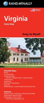
Rand McNally's folded map for Virginia is a must-have for anyone traveling in or through the state, offering unbeatable accuracy and reliability at a great price. Our trusted cartography shows all Interstate, U. S., state, and county highways and much more. Points of interest. State park chart. State mileage chart. Driving times map. On-the-road toolbox. Visitor center information. Climate data. State facts & symbols. Easy-to-use legend. Detailed indexed. Coverage Area: Detailed maps include, Alexandria/Arlington, Bristol, Charlottesville, Hampton Roads: Norfolk/Newport News/Virginia Beach, Lynchburg, Richmond/Petersburg, Roanoke, Shenandoah National Park, Washington, D. C. & Vicinity, Williamsburg/Colonial National Historic Park.
| Medios de comunicación | Libros Hardcover Book (Libro con lomo y cubierta duros) |
| Publicado | 22 de septiembre de 2021 |
| ISBN13 | 9780528025143 |
| Editores | Rand McNally |
| Género | Maps & Guides |
| Dimensiones | 150 × 220 × 20 mm · 500 g (Peso (estimado)) |
| Lengua | Inglés |
Mas por Rand McNally
Mostrar todo


Más del mismo editor


![Cover for Rand Mcnally · Rand Mcnally Providence Street Map (Paperback Book) [Map edition] (2020)](https://imusic.b-cdn.net/images/item/original/153/9780528008153.jpg?rand-mcnally-2020-rand-mcnally-providence-street-map-paperback-book&class=scaled&v=1512788431)
Ver todo de Rand McNally ( Ej. Map , Paperback Book , Hardcover Book , Book y Spiral Book )