Recomienda este artículo a tus amigos:
Rand McNally Folded Map: Atlanta Regional Map


Rand McNally Folded Map: Atlanta Regional Map
Rand McNally
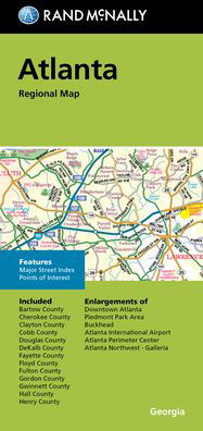
Rand McNally's folded map for Atlanta is a must-have for anyone traveling in and around the Atlanta area, offering unbeatable accuracy and reliability at a great price. Our trusted cartography shows all Interstate, U. S., state, and county highways, along with clearly indicated parks, points of interest, airports, county boundaries, and streets. The easy-to-use legend and detailed index make for quick and easy location of destinations. You'll see why Rand McNally folded maps have been the trusted standard for years. -Regularly updated. -Full-color maps. -Clearly labeled Interstate, U. S., state, and county highways. -Indications of parks, points of interest, airports, county boundaries, downtown & vicinity maps. -Easy-to-use legend. -Convenient folded size. -Major Street Index. -Points of Interest. -Enlargements of Downtown Atlanta. Coverage Area: Communities included, Bartow County, Cherokee County, Clayton County, Cobb County, Douglas County, DeKalb County, Fayette County, Floyd County, Fulton County, Gordon County, Gwinnett County, Hall County, Henry County. Product Details: Measures 9.5' x 4' and folds out to 40' x 28'.
| Medios de comunicación | Libros Map (Cartas terrestres o náuticas) |
| Publicado | 22 de septiembre de 2021 |
| ISBN13 | 9780528025372 |
| Editores | Rand McNally |
| Dimensiones | 106 × 226 × 12 mm · 77 g |
| Lengua | Inglés |
Mas por Rand McNally
Mostrar todo


Mere med samme udgiver

![Cover for Rand Mcnally · Rand Mcnally Folded Map: Fort Lauderdale Metro Street Map (Paperback Book) [Map edition] (2013)](https://imusic.b-cdn.net/images/item/original/996/9780528007996.jpg?rand-mcnally-2013-rand-mcnally-folded-map-fort-lauderdale-metro-street-map-paperback-book&class=scaled&v=1435855826)
Ver todo de Rand McNally ( Ej. Paperback Book , Map , Book , Hardcover Book y Spiral Book )